The United Nations General Assembly has overwhelmingly endorsed a new world map designed to give a more accurate picture of the relative size of the world’s continents, particularly Africa.
The resolution, spearheaded by Togo and backed by members of the African Union, was adopted on Friday, September 4, with 164 countries voting in favour.
The United States was the only country to vote against it, while Estonia, Georgia, Lithuania, Moldova, Serbia and Ukraine abstained.
The resolution, titled “Correct the map: rebalancing global cartographic representation and promoting equitable representation of the world’s regions, particularly Africa,” promotes the use of maps that represent continental land areas more accurately.
Why Africa looks smaller on traditional maps
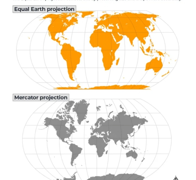
The initiative challenges the widespread use of the Mercator projection, developed by Flemish cartographer Gerardus Mercator in 1569.
The projection was primarily designed to assist maritime navigation. While it preserves directions and angles effectively, it significantly distorts the size of landmasses, particularly as they get farther from the Equator.
As a result, Europe, North America and Greenland appear considerably larger than their actual land areas, while Africa and South America appear smaller.
For example, Greenland can appear roughly comparable in size to Africa on a Mercator map.
In reality, Africa covers about 30.3 million square kilometres and is approximately 14 times larger than Greenland.
Africa is also large enough to contain the United States, China, India, Japan, Mexico and much of Europe, according to comparisons highlighted by advocates of the campaign.
Enter the Equal Earth map
The UN resolution encourages the adoption of the Equal Earth projection, which was developed in 2018 by cartographers Bojan Šavrič, Tom Patterson and Bernhard Jenny.
Unlike Mercator, Equal Earth is an equal-area projection, meaning it preserves the relative sizes of continents and countries much more accurately.
Africa therefore appears substantially larger, while Europe, North America and other northern regions appear smaller than they do on Mercator maps.
The projection is not completely free of distortion because representing a three-dimensional globe on a flat surface inevitably requires compromises involving shape, distance or direction.
However, its main objective is to ensure that the relative areas of landmasses are accurately represented.
Togo leads African campaign
Togo played a central role in pushing the resolution through the UN, with support from African countries and the African Union.
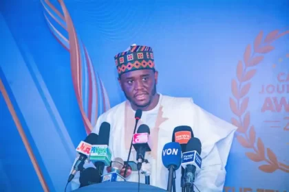
Togo’s Foreign Minister, Robert Dussey, argued that maps do more than provide geographical information.
According to him, maps influence education, people’s imagination and how societies perceive the world.
Dussey described the UN vote as an important step towards correcting the way Africa and other regions have historically been represented.
The campaign has also received support from advocacy groups, including Africa No Filter, which called for accurate maps to be used in schools, textbooks, newsrooms, businesses and digital platforms.
France welcomes the change
France, which co-sponsored the resolution, also welcomed the UN decision.
French Foreign Minister Jean-Noël Barrot said traditional maps give countries such as the United States, Russia and China disproportionate visual prominence compared with Africa, Latin America and Southeast Asia.
He argued that correcting a distorted representation of the world was an important step, even though changing a map does not change the physical world.
Why did the US oppose it?
The United States was the sole country to vote against the resolution.
US representative Yaryna Ferencevych criticised the initiative, arguing that the UN should concentrate on more pressing international issues rather than what Washington described as a map-related ideological project.
The US opposition did not prevent the resolution from passing by an overwhelming margin.
Will the Mercator map disappear?
Not immediately.
The UN resolution is not legally binding and does not ban the Mercator projection.
Instead, it encourages governments, international organisations, educational institutions and technology companies to consider adopting Equal Earth or other projections that more accurately represent continental areas.
The Mercator projection is also expected to remain useful for some navigation purposes because of the way it represents direction.
Togo has indicated that it intends to update its school geography materials as part of efforts to promote the new representation.
Africa’s size in perspective
Africa has a land area of about 30.3 million square kilometres, making it the world’s second-largest continent.
Latin America covers roughly 20 million square kilometres, while Oceania accounts for about 8.5 million square kilometres.
South Asia covers approximately 5.1 million square kilometres, despite being home to around a quarter of the world’s population.
Together, these regions account for more than 40 per cent of the world’s land surface, underscoring the scale of the distortion created when their land areas are represented on conventional Mercator maps.
The UN decision therefore does not literally redraw the Earth.
Instead, it seeks to change how the world is visually represented, particularly in education and other settings where maps shape people’s understanding of geography.
The vote marks a major victory for the African-led “Correct the Map” campaign and could influence the maps used in classrooms, publications and digital platforms around the world.